Our Region – The Far North of South Australia
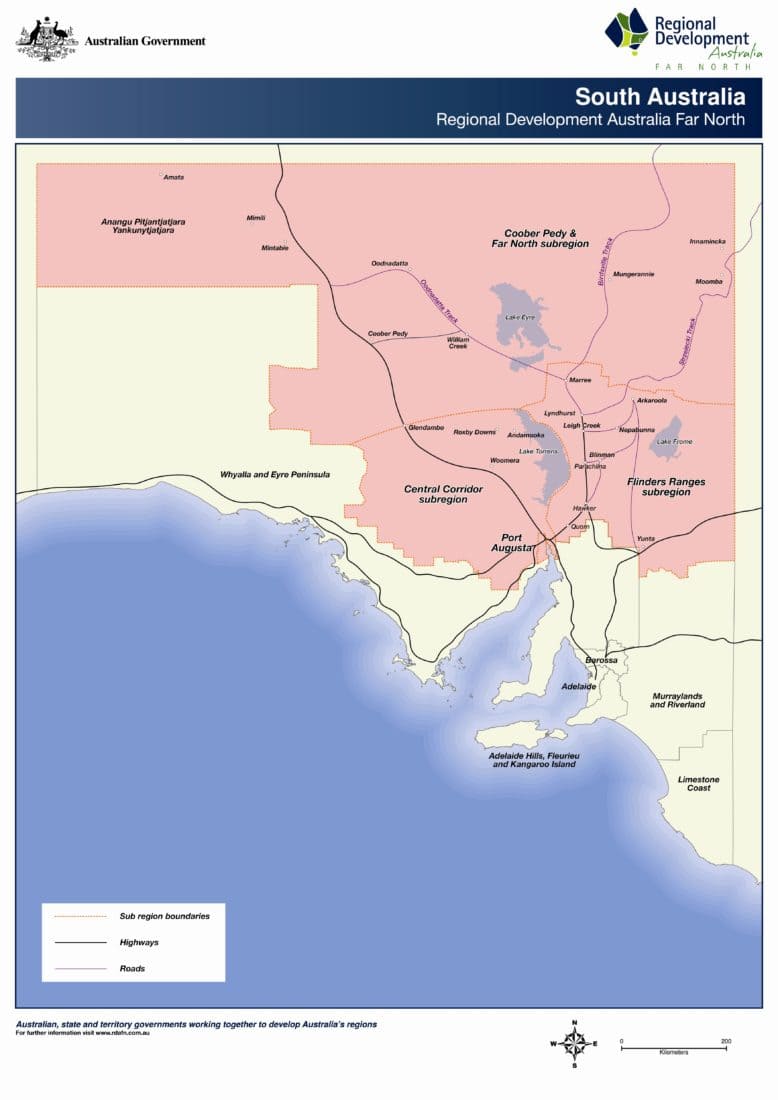
Regional Development Australia (RDA) Far North covers a vast region of 799,850 square kilometres which takes in the sparsely settled country of the north of South Australia. It accounts for 80% of the State's land mass and has a population of approximately 26,365 (2020 ERP) people. Port Augusta is the largest community in the region and acts as a vital service centre for the region's widespread and diverse, small and micro communities.
The region incorporates two of Australia's tourism icons - the Flinders Ranges and the Outback. It also contains the majority of SA's priority mineral exploration regions and the cross roads of Australia's national land transport network.
Significant opportunities for economic growth in the northern region exist in the sectors of resources, tourism, transport, defence, services, food and arts. RDA Far North is committed to fostering this growth for the benefit of the Far North regional community.
Far North South Australia is roughly defined as the area from the Aboriginal Lands on the Western Australian border following a line east along the Eyre Highway incorporating the Gawler Ranges to Yunta and Cockburn in the east, and all areas northwards to the Queensland and Northern Territory borders. RDA Far North acknowledges and respects the traditional owners, their ancestors and the sharing of lands on which the region is located. For operational purposes RDA Far North breaks the Far North region into four sub-regions:
Port Augusta is the largest city in the region, covering an area of 1,153 square kilometres with a population of 13,697 (2020 ERP). Port Augusta is the major service centre for the mid and far north of South Australia.
The Flinders Ranges sub region covers an area of 4,130 square kilometres with a population of 1,688 (2020 ERP) people. The majority of the population resides in the townships of Quorn, Hawker and Cradock. The major industries in the Council region are tourism and agriculture, with mainly cropping in the southern area moving to pastoralism further north into the region.
The Central Corridor sub region covers from Port Augusta through to Andamooka; the majority of this region is made up of large scale pastoral properties and includes towns such as Pimba, Woomera, Roxby Downs and Olympic Dam mine.
The Coober Pedy and Far North South Australia sub region covers the area north of Pimba through to the Northern Territory, Western Australia, New South Wales and Queensland borders. This is made up of large scale pastoral properties, the Anangu Pitjantjatjara Yankunytjatjara (APY) Lands, small communities, and a number of mines.

